Remembering the 1974 Grand River Flood in Cambridge, Ontario

A front-end loader carries people over Grand River flood waters in downtown Cambridge, Ontario.
A front-end loader carries people over Grand River flood waters in downtown Cambridge, Ontario, on May 17, 1974. Image from Cambridge Reporter Collection at City of Cambridge Archives

The last big flood of the Grand River through Cambridge happened May 17, 1974, leaving behind $6.7 million in damages.

That’s $42.5 million in 2024 dollar value, according to the Bank of Canada inflation calculator.

Nobody died, but several people were rescued from the surging waters by firefighters, police and bystanders. One man was pulled from a tree in mid-river by helicopter, according to news clippings at the City of Cambridge Archives.
youtube placeholder image
The Grand River Conservation Authority produced this film about the 1974 flood.

The river peaked at 4.8 metres – 16 feet – above normal level and inundated much of downtown Cambridge.

Remembering the Flood of 1974

Fifty years after the 1974 flood, an event remembers the flood and talks about emergency preparations for future disasters.  The free event runs May 4, 2024, at the Cambridge Fire Hall Museum and Education Centre, 56 Dickson Street, beside Cambridge City Hall.  

Displays are open 9 a.m. to 2 p.m., says Ingrid Talpak, one of the organizers.

Grand River flood waters creep up Dickson Street at Ainslie Street in a photo taken from the Cambridge City Hall tower.
Grand River flood waters creep up Dickson Street at Ainslie Street on May 17, 1974, in downtown Cambridge, Ontario. Photograph taken from the Cambridge City Hall tower. Image from Cambridge Reporter Collection at City of Cambridge Archives.

The event is a partnership between the Cambridge Fire Department, IdeaExchange library, City of Cambridge Archives, Cycling and Trails Advisory Committee, and McDougall Cottage Historic Site.

Displays will include rescue craft used today on local waterways. For example, a fire department airboat can manoeuvre through shallow water or crunch over winter ice.

The Fire Hall Museum partnered with Jane’s Walks Waterloo Region to offer several guided walking tours from the Museum to the Idea Exchange Old Post Office. They will highlight points of interest and high-water marks from the flood of 1974.
youtube placeholder image

A Beautiful, Sunny Day in May

May 1974 had been unusually wet.  On Thursday, May 16, an overnight thunderstorm dumped 50 mm of rain across the saturated Grand River Watershed.  

Upstream reservoirs behind dams couldn’t contain all the rainfall. The Grand River Conservation Authority would later say it warned officials in Cambridge at 11 p.m. Thursday that high water levels were expected.

City officials said the conservation authority didn’t hint at how bad things would get, according to news stories in the Cambridge Daily Reporter newspaper on file at the city archives.

People wade across flooded Water Street at Main Street in Downtown Cambridge on May 17, 1974.
People wade across flooded Water Street at Main Street in Downtown Cambridge on May 17, 1974. Image from Cambridge Reporter Collection at the City of Cambridge Archives.

The last big flood in the Grand River came during Hurricane Hazel in cold October weather in 1954, twenty years earlier.
youtube placeholder image

Friday, May 17 dawned sunny and warm. By 11 a.m., the river was rising.  By noon, water was over the banks downtown – and still rising.

Man carries bicycles over shoulder through flood on Water Street in Cambridge
A man carries a bicycle over his shoulder through a 1974 flood over Water Street in Cambridge. Image from Cambridge Reporter Collection at the City of Cambridge Archives.

Businesses, churches and residents tried to move valuable items above the rising water.  Citizens helped firefighters rescue people from the filthy water rushing through town.  

Some downtown workers were trapped in the offices when they left for work. They didn’t learn about the rising water until too late. Some were rescued in the bucket of a front-end loader, which carried them over the flood waters.

A man drinks from a water fountain as Grand River flood waters rush past his knees on Water Street in downtown Cambridge, Ontario, on May 17, 1974. Image from Cambridge Reporter Collection at the City of Cambridge Archives.

A boil-water advisory later was issued, as government officials feared contamination of the drinking water system.

And on Water Street near Parkhill Road, a fire started in the former Hahn Motors car dealership near the river.  Flames gutted the building as firefighters struggled to reach the building by boat.

Firefighters shown working at a burned-out car repair shop as flood waters recede in Cambridge, Ontario on May 18, 1974.
Firefighters work at a burned-out car repair shop on Water Street near Parkhill Road on May 18, 1974. The building caught fire the day before, during a flood of the Grand River in downtown Cambridge, Ontario. Image from Cambridge Reporter Collection at the City of Cambridge Archives.

It took more than two months for downtown businesses to clean up and recover from the damage, according to Cambridge Reporter news clippings.

Workers use mops to clean in a store after the Grand River flood on May 17, 1974, in downtown Cambridge, Ontario.
Cleaning up in a store after the Grand River flood on May 17, 1974, in downtown Cambridge, Ontario. Image from Cambridge Reporter Collection at City of Cambridge Archives.

21 Recommendations from Flood Inquiry

There were 21 recommendations from an Ontario government inquiry into the disaster. It heard 43 days of testimony.

Key recommendations included an expanded flood prevention plan throughout downtown.   More than $20 million was spent on flood control and property purchases in the following 15 years.

A sign on the Capitol Theatre marquee makes fun of the severe Grand River flood with a modified movie title: The Three Musketeers Under Water
A sign on the Capitol Theatre marquee makes fun of the severe Grand River flood on May 17, 1974 in downtown Cambridge, Ontario. Image from Cambridge Reporter Collection at City of Cambridge Archives.

For several years in the mid 1980s, construction crews blasted into bedrock to lower the river channel.  At the same time, taller flood walls and berms rose along the river, with the goal of containing another flood of the scale of 1974.

The conservation authority and city blamed each another for delayed flood warnings at the inquiry.  Judge Wilfred Leach absolved the conservation authority of blame at the inquiry.  He also insisted on a better flood warning system.

That recommendation led to a network of water-level monitors across the watershed.  Every year, flood coordinators in cities, towns, and townships across the Grand River watershed test the alerting system. 

Flood Warnings Now on Social Media

The public part of the warning system began with regular releases to local newspapers, radio and television stations. Today, public outreach includes social media, email alerts and live river-level data displayed on the conservation authority’s website. 

Every year, city public works crews also practice installing portable flood walls at ends of the three bridges along the Grand in Galt.  The bridges are lower than the raised flood walls, leaving a gap in flood protection.  

If high water is expected, city crews collect kits of pre-cut aluminum posts and logs.  The posts are dropped into pre-made sockets in the road at each end of the bridge.  In between, more sections are dropped into place horizontally.  To waterproof and buttress the temporary walls in a real flood, thousands of sandbags would be filled and stacked behind them.

A map showing the extent of Grand River flooding on May 17, 1974 in Downtown Cambridge.
A map showing the extent of Grand River flooding on May 17, 1974 in Downtown Cambridge. Image from Grand River Conservation Authority and presented at a public information session about the flood on April 25, 2024, at the IdeaExchange Old Post Office library.

Railway repairs closed Blair Road at bridge in West Galt, Cambridge ON

youtube placeholder image

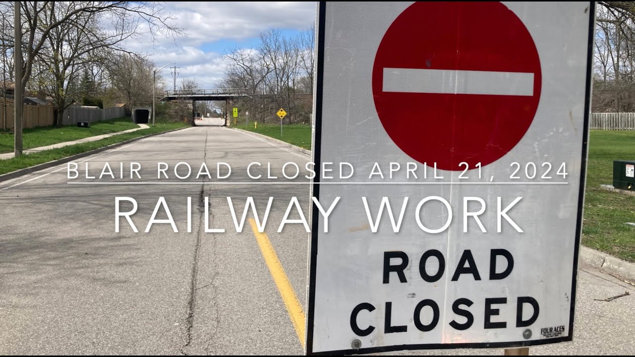
Blair Road in West Galt was closed to traffic on Sun., April 21, 2024, for railway maintenance.

Canadian Pacific Kansas City Railway crews worked on the tracks and ties for the Galt subdivision main tracks through Cambridge.

Blair Road was closed between Bismark Drive and Kenmore Avenue for the day as the work progressed overhead on the tracks.

Grand River Transit closed the bus stop at Blair and Kenmore for the day, even though the Route 57 bus doesn’t run on Sundays under the railway bridge.

Blair Road was closed for CPKC railway track repairs April 21, 2024

Wind storm claims one of my favourite old pine trees in West Galt

One of my favorite pine trees was brought down overnight in Cambridge Ontario in Mount View Cemetery.

Winds of upwards of 80 kilometers an hour blew through my West Galt neighborhood and took down this grand old pine tree in Mount View Cemetery

The cemetery opened in 1869 and is home to dozens and dozens of grand old trees.

youtube placeholder image

Another All-Way stop for Blair Road in West Galt May 6, 2024

All-way stop sign at Blair Road and Bismark Drive in Cambridge, Ontairo.
All-way stop signs were installed on May 6, 2024, at Blair Road and Bismark Drive in Cambridge, Ontario. New crosswalks were also painted in the intersection. Photo by Kevin Swayze

Update: All-way stop signs were installed on May 6, 2024, at Blair Road and Bismark Drive in Cambridge, Ontario.

New crosswalks were also painted at the intersection, in all four directions.

All-way stop signs are coming to Blair Road and Bismark Drive in West Galt, six months after all-way stop signs were installed nearby at Blair Road and Grant Street.

According to signs posted at the intersection, the Blair-Bismark all-way stop signs installation is set for May 6, 2024.

Salisbury-Hardcastle All-Way Proposed, too

And residents of the Salisbury Avenue and Hardcastle Drive area may also get the all-way stop they want at that intersection, too.

There, people have been asking the City of Cambridge for traffic safety changes since 2020.

$1,200 cost for All-Way

Cambridge City Council unanimously voted to spend $1,200 to install more stop signs at the Blair-Bismark intersection on February 27, 2024. The work included new pavement markings.

It’s a busy route for students walking to nearby St. Augustine Catholic Elementary and Blair Road Public schools along Bismark. The schools are located to the west and east sides of the intersection.

The all-way stop was installed at Blair-Bismark due to concerns raised by area residents, says a staff report to City council on February 27, 2024.

Blair-Grant All-Way Stop

In November 2023, the city installed all-way stop signs at the Blair-Grant intersection near Mount View Cemetery.

That’s about a kilometre south of Blair-Grant. That’s at the start of the one-way section of Blair Road towards downtown.